(Directions: Take Arkell Rd. east from Watson Road about 2 kilometres: sign indicates Starkey’s Hill.)

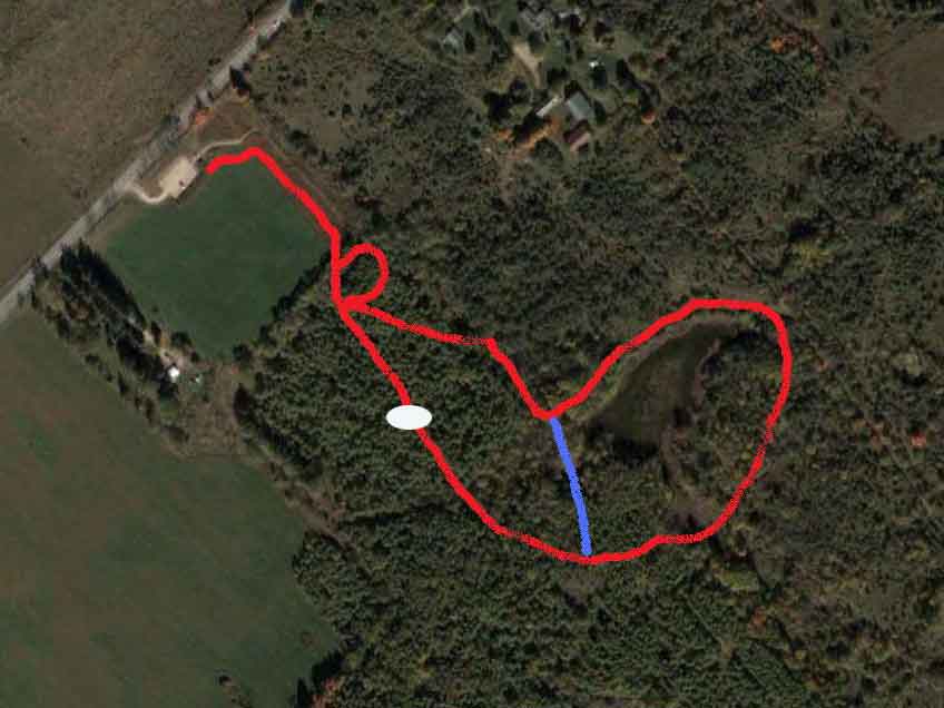
The parking lot at the top of the map is in rough shape. It is also quite possibly the only thing correct about the map as I am not sure exactly where the trail goes except that it generally follows a big loop, with a shortcut in the middle (the blue line). Another map can be found here. (Use the zoom controls to enlarge it: this is probably a more accurate map.) I am told the trail is about 4 km long.
Follow the trail through the field from the parking lot into the woods. (You can see the actual path in the above map as I drew the red line beside it.) You have an immediate choice of going right or left but it doesn't matter: you are at the bottom of a small circular trail and will end up at the same point whichever way you go. There is a clearing at the top end of this small circle and once again a choice of left (really straight ahead) or right. I tend to go straight ahead because if you go right you are going hard uphill to the highest point of the hill (the white circle on the map) and I prefer to take the gentle approach as well as saving the high point for the end. This trail is marked by blue blazes.
Stay left on all the turns and cutoffs so that you stay on the outside of the hill: otherwise you will be cutting the walk short. Be warned: there are lots of burrs on this trail and lots of muddy sloughs all along the way at the bottom of depressions. And I mean stinking, clinging black muck that you will have no opportunity to get off your dog until you get home. Try to keep him up on the trail and stop him from going down into these sloughs.
At just under a kilometer from the start you will come to a split in the trail where there is a sharp left turn down a fairly steep hill while another path goes off to the right. If you take the right path you are cutting off part of the trail. Go left down the hill. The trail will become windy and there are some up and down portions, some of which can be either slippery in winter or muddy in spring or wet weather. After a number of ups you will be at the top of the hill. There are some good views of Guelph from here, including the Church of Our Lady. There is a also a park bench so you can catch your breath and a plaque dedicating the site.
From here is it mostly downhill back to the original loop and out to the parking lot. No problem getting the dogs in and out of the car in the parking lot: it's a good way from the road.