(Directions: North out of Guelph on Victoria Rd. about 1.5 km north of Woodlawn. Park on either side of road at Speed River.)
The trails that lead from here up to and around Guelph Lake are maintained by the Guelph Off Road Bicycling Association. I find this group unfailingly polite, giving ample warning when they approach hikers from behind by squealing their brakes or changing gears. Please control your dogs and let them pass without interference. They like the challenging terrain and avoid the wider paths for the most part. GORBA's map of this area is available as a pdf file. (My map does not show all of the lake.)
Parking is allowed along the side of the road on Victoria Rd., just south of the river. There are usually cars there. Take the trail that leads east from Victoria Road with GORBA signs on it. This is a continuation of the trail that runs from Riverside Park and you can see the entrance to this trail on the west side of the road.
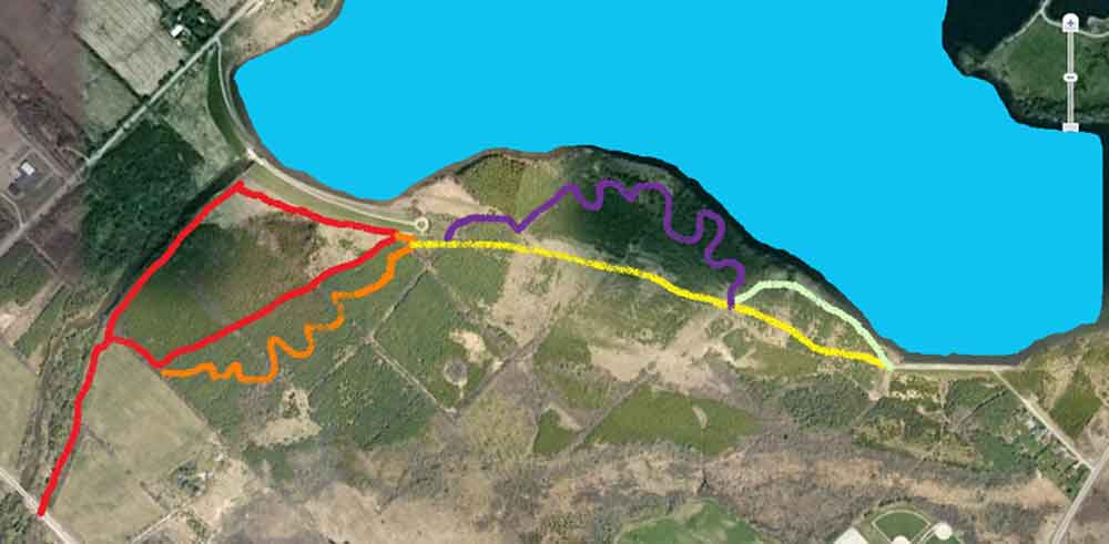
The simplest way is to follow the red trail taking no side paths, all the way to the dam. Just keep the river on your left. Soon after you start you will walk beside a cultivated field and the path will then enter the woods. Ignore the path that leads off to the right just after you enter these woods: you will return by it. It is less than 10 minutes to the dam from here. Turn right at the base of the dam and follow the trail to the far end (big incline). Just at the beginning of the big incline you can pick up a trail that runs on your right diagonally away from the dam, at first just skirting the woods but entering them fairly shortly. This trail will make a sharp right turn just before the cultivated field and take you back to the river and out.
For a longer walk make the right turn just after passing the cultivated field. After a few minutes you will come to where the red trail turns sharply left to go through a long corridor of trees (looks like an aisle in a church): Instead of turning left, continue straight ahead (orange trail on map). This trail intersects many others (not shown) and winds its way up to the south end of the dam where you can pick up the red trail again.
The yellow path on the map is a fairly straight trail toward the other end of the lake. There are many intersecting trails here, not shown but great to explore. The purple trail is a challenging up and down trail to the water and back up the hill several times, well used by bikers. At the junction of the yellow, purple and pale green paths is a pile of rocks where you can take a rest and enjoy some of the nicer views of Guelph Lake and the island.
You can continue around the shore of Guelph Lake after end of the yellow path by crossing the cement causeway. Great places for the dogs to swim here. After a while, however, the trail gets pretty close to Highway 124.
Someone else with a lot more savvy has done another map of this area.
This is probably a much more accurate description of the area. Use the zoom controls to enlarge the map.