(Summary: Go west from the Hanlon on College then take the first right, Dovercliff, and park at the curve in the road just ahead. The path goes downhill beside the fence.)
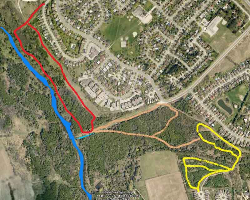
Crane Park is a designated off leash area, one of the best. It is the red path on the map. Follow the pathway down from the road beside the fence and into the woods. The path on the left just after the end of the fence is your return path. Leave it for now and go straight ahead down into the woods almost to the river and turn left. At one point you cross a gully which may or may not have water in it: the city controls the flow.
Keep going straight ahead and you will eventually come out to a clearing (X on the map). On your right will be the river. On your left, about 2/3 of a kilometer away is the intersection of College and Stone Road. The cleared area appears to me to have once been Stone Road that went right down to the river.
At this point I generally go down to the river and let the dogs swim.
You have two choices at this point. The first is to follow the red path back to the starting point. Most of this trail is out in the open behind the houses on Conroy Crescent and Dovercliffe. Just walk east towards Stone Road about 50 yards and you will see the path on your left going back into the woods to take you back. It very quickly comes back out of the woods and the rest of the trail back to the car is in the open field.
The second choice is to extend this walk by not going back left into the woods. Instead, cross the stream on the other side of the road and follow the brown trail on the map. Look for stones or wood in the stream to allow you to cross. The crossing is a little difficult because the stones keep moving. But once across you will pick up a yellow blazed trail heading diagonally away from the stream. In a short while you will see a fence on your right and this is the former Kortright Bird Sanctuary. The path turns left, then right and you need to keep your eye open for a path leading left to take you out of the woods. This path takes you to a very clear path that runs from Stone Road for some distance along the backs of houses: you can see the line on the map above. You want to get your dogs on leash when you come out of the woods, turn left and come out at Stone Road. You will see a parking area on your left and the path that goes back down to the river where you started. Go back down and enter the woods on the return leg of the red trail.
If you don't spot the brown trail that goes left you will come out in a small clearing by the stream. It is possible to find a trail that winds away from this clearing through the incredible blowdowns here to get you to the yellow trail on the map. The yellow trail has a loop that runs through the woods on the west side of the stream and behind some houses, while there are several loops on the east side of the stream that take you through the woods and up to Ptarmigan. There is a small bridge to take you over the stream at the south end of the trail. I often just park on Ptarmigan and do the yellow trail only.
The large cleared area bordering the yellow trail on the map is the former Kortright Bird Sanctuary. It is fenced off and between spring and fall you will often see numbers of deer under the trees at the far side of the clearing. You will notice that they will all be staring at you as you walk by.